
Josephson Concrete and Hardscapes · September 29, 2026 · Shoreline and riprap
Stopping Shoreline Erosion on Wright County Lakes
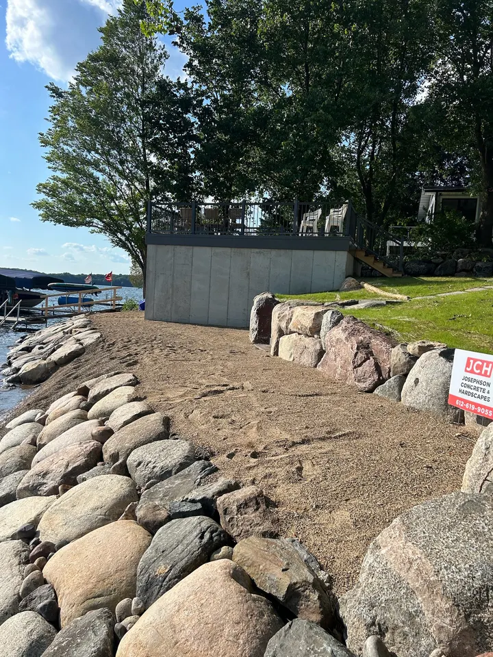
The short answer: lake banks around Wright County fail from three forces working together: waves eating the toe of the slope, ice pushing on the shore during spring breakup, and runoff carrying soil down from the yard. The fix is to armor the waterline with rock, hold the slope above it with a boulder wall or a regraded and planted bank, and get roots into the soil so the hill holds itself. Nearly all of this work touches public waters, so it usually involves the DNR and the county before the first rock goes in.
We build shoreline on lakes from Annandale and Maple Lake down to the Meeker County line, and the bank problems we see are the same across the region. Here is how we think about them.
Why lake banks fail
Waves
Wave action is constant and it works at the one place a bank is weakest, the toe of the slope where the water meets the soil. Each wave pulls a little sediment out. Over a season that undercuts the bank, and the soil above it slumps down to fill the gap. Boat wakes on a busy lake do the same work faster. A bank that looks fine from the house can be hollowed out at the waterline.
Ice
Spring breakup is the force most people from outside Minnesota do not think about. Ice sheets expand and shift with temperature and wind, and they push against whatever is at the shore. An ice ridge can shove soil, docks, and small rock up the bank in a single afternoon. Lakes here get this every year, and a shoreline that was not built for it gets rearranged.
Runoff
Water coming down from above does as much damage as water coming from the lake. A roof, a driveway, and a lawn on a slope all send rain and snowmelt toward the water. On a bare or thinly grassed bank that runoff cuts channels and carries topsoil straight into the lake. Bare slopes are the worst case, and a bank that has been stripped for construction or trampled by foot traffic is a bank that is already failing.
Put all three together and you get the pattern we see on most calls: an undercut toe, a slumping face, and gullies from above. The bank gets steeper as it fails, and a steeper bank fails faster.
Riprap, boulder walls, and native plantings
There are three main tools, and most banks need more than one.
Riprap
Riprap is a layer of angular or rounded rock placed along the waterline over a filter of gravel or fabric. It works by breaking up wave energy against a rough surface and by letting water move in and out through the gaps without carrying soil with it. Done right, it holds the toe of the slope, which is the whole game. Done wrong, with rock dumped on bare soil and no filter, the fine material washes out from underneath and the rock sinks or slides.
Riprap is the workhorse. It is what the DNR points people toward when a bank has real erosion, and it is what we build most often.
Boulder walls
A boulder retaining wall is for the slope above the water, where the bank is too steep to hold itself. Large natural boulders are set into the hill, leaning back, so their mass carries the weight of the soil behind them. A boulder wall is not a straight vertical face like a seawall. It steps and leans, which is why it lasts and why it is allowed where a vertical wall at the water is not.
The wall and the riprap work together. Rock at the toe keeps waves off the base of the wall. The wall holds the hill so the riprap is not buried by slumping soil.
Native plantings
Roots hold soil. A bank planted with deep-rooted native grasses, sedges, and shrubs above the riprap holds its own topsoil, slows runoff, and filters what does come down. On a gently sloped bank with mild wave action, plantings alone can be enough, and the DNR would rather see a planted shore than a rock one where a planted shore will work.
On a steep bank that has already failed, plantings alone will not hold. They need a stable slope to root into, which is where the grading, the riprap, and the wall come first. We finish nearly every shoreline job by seeding or planting the slope above the rock, because a bare bank above good riprap is still a bank that erodes.
The DNR permit basics, in plain language
Most lakes in Wright County are public waters, and the state regulates work at and below the ordinary high water level, which is the line the DNR uses for where the lake legally begins. Here is the short version of how it usually works. Verify the details with the DNR area hydrologist and the county planning office for your lake before starting, because rules change and every lake has its own designation.
Riprap that meets the DNR’s standard usually does not need a permit. That standard, as of this writing, is roughly: natural rock that averages between six and thirty inches, placed no more than about six feet out from the ordinary high water level, finished at a slope no steeper than three feet out for every foot up, laid over a filter layer, following the natural line of the shore, not covering emergent plants, and only where there is existing erosion to fix. Riprap for looks, or to replace a shore that is already stable and vegetated, is not what the exemption is for.
Anything bigger, steeper, or farther into the water usually needs a public waters work permit from the DNR. Retaining walls at or below the ordinary high water level are generally not allowed for new construction, and the DNR discourages them because they reflect waves and scour the lakebed in front of them.
The county has a second set of rules under its shoreland ordinance. Wright County, for example, treats grading of more than a set volume in the shoreland district as a conditional use and has its own limits on how far riprap can extend landward and how high it can sit above the water level. Meeker County has its own version. So the honest guidance is: riprap done to the state standard is usually fine, boulder walls above the water are usually fine with county sign-off on the grading, and anything at or in the water beyond the standard needs a permit. We walk customers through this before we quote, and we build to the standard so the permit question stays simple.
What the Lake Sylvia job looked like
Lake Sylvia sits southwest of Annandale in western Wright County, two lakes joined by a channel with deep, clear water and a lot of shoreline. The lot we worked had a bank that showed all three failures at once. It was steep, it was bare, and it was actively slumping toward the water. Nothing at the waterline was absorbing the waves and nothing on the slope was holding the soil.
We brought in a compact excavator so we could work the slope without tearing up the rest of the lot, and we graded the hill to a stable angle. The waterline went in first: rounded fieldstone packed tight along the shore to hold the toe. Then we worked uphill with large natural boulders, seating each one into the bank to build a retaining wall that carries the weight of the hill. Above the wall we finished the slope with topsoil and seed.
The order matters. Toe first, then the wall, then the slope. Build it the other way and the wall sits on an undercut bank and the seed washes out. You can see the finished work on our Lake Sylvia project page.
Signs your bank needs attention
- A visible undercut or overhang at the waterline
- Cracks or slumps in the slope face
- Gullies or bare channels running down from the yard
- Exposed tree roots along the shore
- A dock or stairway that has shifted or tilted since last year
- Cloudy water at your shoreline after a storm when the rest of the lake is clear
Any one of these means the bank is moving. Two or more means it is time to look at it before the next spring breakup.
Getting it looked at
Shoreline work is easiest when it is planned: the right water level, firm ground for equipment, and any permit question settled before the crew shows up. We build shoreline, boulder retaining walls, and drainage and erosion control on lakes across Wright and Meeker counties. If your bank is slipping, we will come out, look at the toe and the slope, and tell you which of the three tools it needs.
Want us to look at your yard?
Free written estimate, measured in person, same-day callback.
Questions we get asked
Do I need a permit to put riprap on my lakeshore in Minnesota?
Usually not, if the riprap meets the DNR's standard: natural rock of roughly six to thirty inches, placed no more than about six feet out from the ordinary high water level, on a slope no steeper than three to one, over a filter layer, and only where there is real erosion. Anything beyond that needs a public waters work permit. Check with the DNR area hydrologist and the county before you start.
Can you build a retaining wall right at the water's edge?
New retaining walls at or below the ordinary high water level are usually not allowed on Minnesota public waters, and the DNR discourages them because they reflect waves and scour the lakebed. Boulder walls above the water level, set back on the bank with riprap at the toe, are the common approach. The county also has shoreland rules on grading and setbacks.
Is riprap or a boulder wall better for a lake bank?
They do different jobs. Riprap protects the waterline from waves and ice. A boulder wall holds a steep slope above the water. Many banks need both: rock at the toe and a wall or a regraded, planted slope above it. A gentle bank with mild wave action can often be held with native plantings alone.
How long does shoreline work take?
The construction itself is often a matter of days for a typical residential lot. The permit review, if one is needed, and the wait for the right water level and ground conditions can take longer. We plan shoreline jobs around low water and firm ground so the equipment does not tear up the lot.